Kingfisher
chasing forest in the indio maiz reserve
By Trevor Ritland

This is Chloroceryle amazona, photographed in the Indio Maiz Reserve in southeastern Nicaragua. I've taken photos of these Amazon Kingfishers and their relatives from southern Arizona all the way down through Central America, but this one stands out in my memory above the others— likely due to the circumstances that accompanied the sighting. Last November, I was in a canoe traveling up the Rio Frio on the edge of the Indio Maiz Reserve, accompanied by three rangers and an independent boat driver. Indio Maiz is one of the last bastions of wild frontier wilderness in Central America, but its security is currently obscured by the shadow of rampant and unchecked deforestation on the fringes of the reserve.
When I heard about the silent destruction of this goldmine of biodiversity, I first turned to Global Forest Watch, an online application that allows users to monitor forest loss, land use, and commercial development all over the globe and in real time. From 3000 miles away, I traced the path of the deforestation, spreading from the veins of the river like infection through a body. It looked as though the encroachers were using the river as their entry-point; traveling up the cool waters by boat and then, a few miles in, pushing in to the reserve where they thought their presence might go unnoticed.
“Nicaragua Quiere Saber” is a Facebook community page with a mission to keep the Nicaraguan public informed about the issues that affect them— including the proposed Interoceanic Canal and the impending deforestation of Indio Maiz. Over email, I conversed with one of the administrators of the page (who wished to remain anonymous) about the reasons for the perceived deforestation of the reserve. She told me that the primary motivation for the influx of small landowners is the belief that their actions will go unnoticed; or at the very least, uncontested. “They can get in and deforest and bring in cattle or make some road, or re-sell the land and no one will stop them,” she says. In her experience, the intruders are mostly small-scale farmers and their families— either local or from a nearby province. In the case of the locals, these families most likely sold their land near the edges of the reserve and bought a new and better plot inside, unaware or not caring that their new land was not actually for sale. As for the not-so-local families, the admin of NQS offered her perspective: “they also sold their land; they are looking for a place to live for the first time, or because they are afraid to lose their land because of the proposal of the Nicaraguan interoceanic canal.”
She tells me that the big corporations— oil palm, gmelina, sugar cane— have not yet made their way into the reserve, but that does not mean that they are innocent in the cutting inside the boundaries. The NQS admin explains, “big gmelina and oil palm plantations are buying land from people who live in the surroundings, so these families and farmers are getting ‘new' lands in the reserve.”
So it wouldn’t be unfair to say that, were monocrop corporations not creating a market for land around the reserve, local families would not feel as entitled to sell their plots and would not now be pushing into Indio Maiz in search of new land.
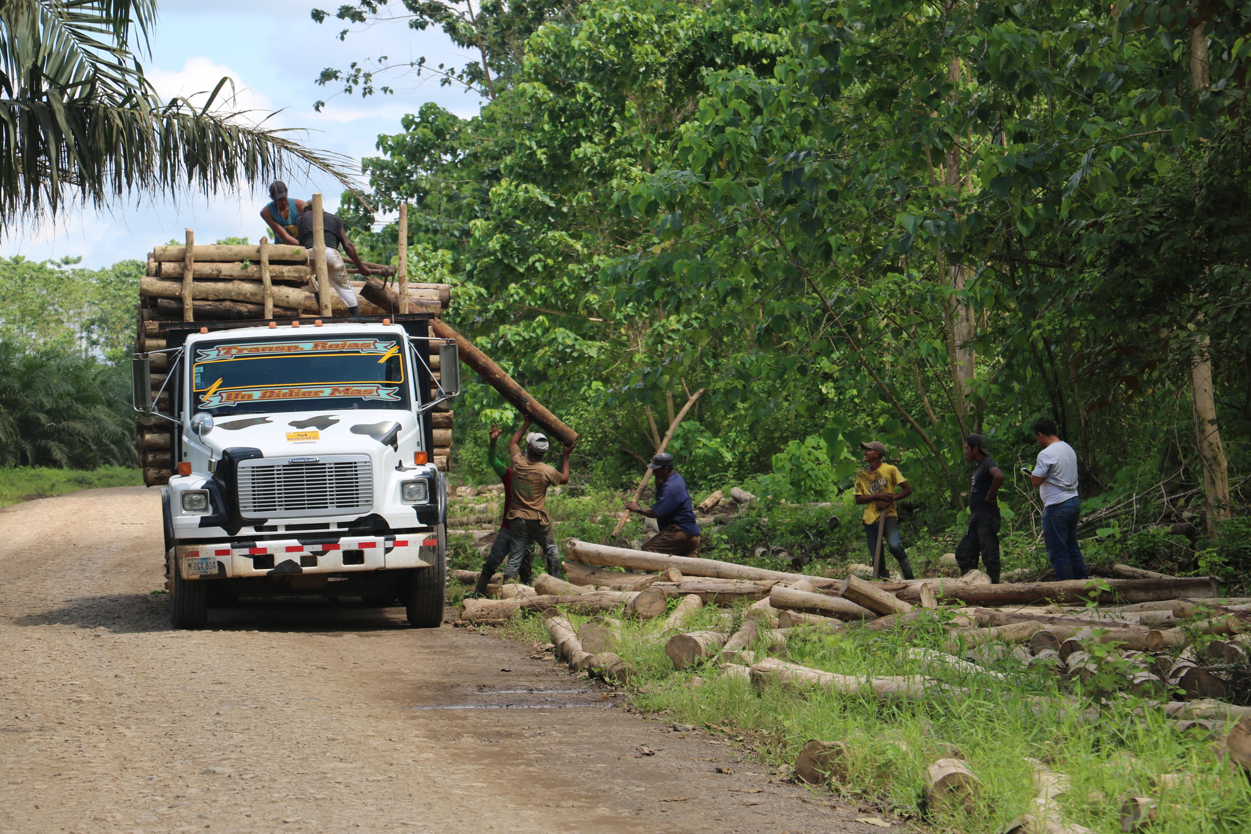
Laborers loading up Gmelina just outside the borders of the Reserve
I learned everything I could from afar, but it soon became clear that to really understand what was happening inside the boundaries of the reserve, boots were going to have to hit the mud. When the study abroad group that I was working for as a teaching assistant traveled to El Castillo, Nicaragua in November, I took the expedition as an opportunity to find my way into the reserve and examine the forest cover loss in person; for this, I teamed up with an El Salvadorian PhD working with the program named Hector Castaneda. On my day off, we hired a canoe to take us up the Rio Frio and into an area that Hector had identified as a probable location subject to illegal cutting. A conservation biologist with experience in remote forest monitoring, Hector had taken a closer look at the recent aerial photographs of the Indio Maiz Reserve and had identified a peculiar-looking rectangular patch of forest cover loss close to the edge of the protected limit but still within the legal boundaries of Indio Maiz. Since nature doesn't work in straight lines, it was a red-flag location for us; we made this anomaly a few miles up the river our objective.
As we traveled up the rio, Hector sat quietly in the back of the canoe, taking GPS points and small-talking in Nicarguan slang with the rangers, hoping one of them might let something slip about the sorts of people coming up this river in the last few months. I sat apart, taking photos of the thin patches we could see beyond the initial boundary of forest, and of the kingfishers and the cormorants that fished up and down the banks of the shaded river. We passed beneath archways of low-hanging foliage and beneath the shadows of Ceiba trees that the indigenous folklore told us bridged the gap between heaven and the Earth; we passed small homesteads on the river’s edge— legal because they stood on the left-hand side, just across the river which acted as the boundary of the reserve. As we moved further in, however, the reserve would expand its limits and the river would begin to cut into Indio Maiz itself, and we would grow to be surrounded on all sides by protected land.
We had explained to the boteros the precise location of the place we intended to go, and they had responded with assurances that there was nothing there of interest; “Let me take you somewhere else,” they would reply, “there are good places to see— lots of animals. Better places.” Their concerns seemed honest— they were hired mostly by tourists in search of rare birds or Jaguar prints— but we persisted, and the rangers complied. When we pushed the canoes to the bank of the spot that Hector had picked out, one ranger volunteered to take us up into the forest. The others waited at the boats, but did not sit down or attempt to make themselves too comfortable; their body language implied that they expected our investigation— whatever its objective— to be concise.
Hector and I cut our way up the bank and into the sporadic forest. We were very near the reserve’s boundary; a stone’s throw to our left would hit unprotected land, and to our right was Indio Maiz. It was not clear precisely where the reserve ended and the private land began— a possible innocuous explanation for the encroachment on Indio Maiz’s edges. We gained the hillside and sighted a collapsing building, neglected for a decade or so according to our guide; it was a MARENA outpost, Nicaragua’s Ministry of Environment and Natural Resources. Ten years earlier José Daniel Ortega had taken power as President of Nicaragua, and he had not lost an election since, although many had been contested. Hector and I could not help but suspect a correlation between this Sandinista’s rise to power and the abandonment of this key MARENA outpost on the front-lines of protected land.

Ortega's legacy
Hector reminded our guide that this spot was not our destination, and the ranger responded with a reluctance to continue. It was a long way, he said, and we might as well just explore around this area. Hector abandoned his earlier attempts at seeming casual.
“We want to go one-point-eight kilometers in that direction,” he said.
Our guide reminded us that we were on a deadline, and he was right; we had to meet our other boat at 4pm, the one that would take us back up the Rio San Juan and into familiar territory again. If we missed that boat, if they didn’t wait, we would be stranded in the forest at the mercy of the hospitality of whatever landowners we might discover. But we had come this far, and the anomaly was less than a kilometer away; after a brief resistance, the ranger agreed to our request.
He did not do so lightly, however. Gradually after we began again into the forest, his pace began to quicken; a stroll turned into a trot, which grew into a run, which before long evolved into a full-out sprint. The implication was that this was for our benefit— we had a schedule to keep, and according to the ranger the terrain was hard and would try to slow us down. But his over-the- shoulder glances seemed more of a challenge than a check-up; his intent was to wear us down. I was carrying a machete, a daypack, and a DSLR— it was not that impossible of a goal.
We ducked beneath barbed wire fences, jumped streams and scrambled on muddy hillsides, and the ranger never slowed his pace. I began to lose step with him and Hector, my camera weighing me down. As we progressed, I started to suspect that the ranger had a second objective too: besides attempting to wear us down and elicit our regression, he was trying to disorient us. Our non-linear movements up and down the hillsides began to scramble our internal compasses, until we were no longer certain where the private land ended and the Indio Maiz Reserve began. Our serpentine advancement lost to us the landmarks we had kept when we had left the trail, and so when we emerged, finally, to the top of the embankment and looked down on the scene that lay before us, we were no longer sure precisely who held the deed to the scattered forest at our feet.
What we saw when we gained the hill was this: a graveyard of fallen trees, most of them thick with a past of decades, now felled in chaotic ruins like the toppled pillars of Rome. The Kingfisher who had watched us as we’d traveled up the river from the safety of the water’s edge now flitted briefly in among the spectacle, but there was nowhere for him to alight; all of nature’s perches had been felled. For a few hectares, this scene lay out in front of us, but the ranger was gesturing up the hill, along the trocha; now, given the circumstances, he was anxious to take us to the place we had wanted to go. I took a few photos and Hector examined the cuts on the tree stumps; they were clean, fresh, maybe a few days old. In time we started following the ranger once again, leaving the old fisherman to make his home among the rubble.

"Protected" forest
He led us up the trocha, the demarcated boundary between the private land and the Indio Maiz Reserve, where the trees and brush had been cut away in a five-meter-wide gap to form what amounted to a road. The trocha was not well-cleaned and so we took our time to step around the fallen lianas, the branches, the trees all bearing the clean cuts of a chainsaw. The path turned and sprouted up a steep embankment, and it was once we had reached the top of it and stood on the cusp of starting down the mud slope on the other side that the ranger stopped his lead and refused to go any further.
Hector consulted his GPS. “It’s just another point-eight kilometers,” he told me, “but he doesn't want to go. He says it is too steep, it will take too long.”
It didn’t look so steep to me. I didn’t want to push our guide too far beyond his comfort zone, but to be so close and to turn back now seemed impossible. Hector talked to the ranger in Spanish for a few minutes, but it wasn’t doing any good; he wasn’t going any farther. Finally, Hector looked back at me and shook his head. We were going back.
The ranger led us back a different path than he had led us in; this one avoided the ditches and the creeks, the barbed wire and the steep embankments slicked with mud. Where before we had moved in angles and curving transects, we now cut straighter through the forest on the level ground. My suspicions, then, had been well-founded; he had been attempting to exhaust us into a premature regression. As we walked back together, Hector wondered aloud about the ranger’s motives.
“He definitely didn’t want us to see whatever was up there,” he murmured as we picked our way back down toward the river. “He probably knows the guy who cut it and doesn’t want to get his friend in trouble.”
I shook my head; I didn’t know. We walked back down to meet the boats, loaded up our equipment, and headed down the river to catch our ride back into town.
That night, Daniel Ortega would be re-elected President of Nicaragua in an election that multiple Central American electoral regulatory committees had already deemed invalid. His wife would share the ticket as his vice-president. If his history is any indication, Ortega is unlikely to put a stop to the illegal cutting and development inside Indio Maiz until it affects him on a personal level. It is this distance, I think, this detachment, that is the heart of the matter— it is where the roots grow from. If we don't work harder as a species to overcome our inability to empathize with those things beyond our line of sight, places like Indio Maiz will one day slip out of existence.
I did not see the Kingfisher again as we drifted down the river; maybe we had spooked him when we had come into his world so unannounced, or maybe he had heard the rumble of the chainsaws a few hectares in and had taken to the air in search of a new home. I hoped that he would find one before he grew too worn to carry on.
